


Answering the “what”, “how”, and “why” of NERACOOS and ocean observations
The bite-sized answer to, “What does NERACOOS do?”
NERACOOS, the Northeastern Regional Association of Coastal Ocean Observing Systems, is one of the 11 Regional Associations of the Integrated Ocean Observing System (IOOS), and a certified Regional Information Coordination Entity (RICE) encompassing coastal waters from the Canadian Maritime Provinces to the New York Bight. Our mission is to produce, integrate, and communicate high quality information that helps ensure safety, economic and environmental resilience, and sustainable use of the coastal ocean. Since our founding in 2009, we have worked with a wide range of partners to build an observing system for a community of users who depend on the ocean for their livelihoods and culture.
NERACOOS works together with local, state and regional stakeholders to better understand their ocean information needs, so we may develop tools that address the concerns of the communities we serve.
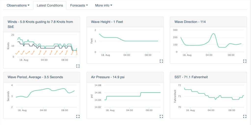
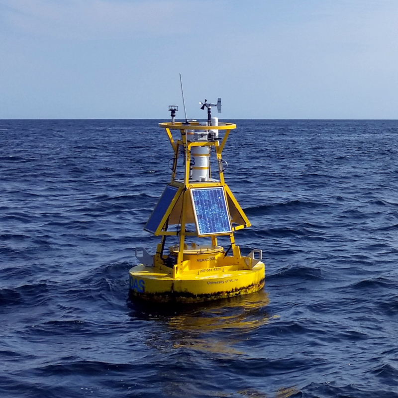
A foundational element of our observing system is an established network of fixed buoys providing real-time and historic data on weather and ocean conditions to mariners, regulators, researchers, and other users. The buoy network is complemented by other fixed stations measuring specific variables at targeted locations; autonomous gliders and vessel-based observing to provide more widespread and flexible coverage; high-frequency radar that is particularly important for search-and-rescue operations; and satellite observations at a regional scale. These observing tools complement modeling systems that produce forecasts and historical trends of ocean and weather conditions. Observing data and forecasts are delivered through data products that make large data streams accessible and understandable for users.
NERACOOS observations and model predictions are used extensively by maritime operations in the Northeast, especially to support maritime safety decisions. The data and services we provide are also used for assessment and planning by coastal resource and water quality managers, emergency managers, consulting companies, aquaculture companies, energy companies, formal and informal educators, recreational boaters, and coastal property owners. Our observations and forecasts are relied upon by National Weather Service (NWS) Weather Forecast Offices to verify and improve forecasts; United States Coast Guard (USCG) stations to plan search-and-rescue operations (SAROPS); and commercial and recreational mariners to make operational decisions.
We are proud to deliver high-quality information that can be used to protect lives and property, support economic resilience, empower coastal communities, and improve the health of our oceans.
Ocean observations are data, both real-time and historical, on wave height, wind speed, water temperature, visibility, saltiness of the water, current speed, location and abundance of animals, and more.
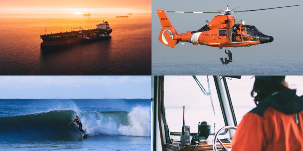
Ship captains, scientists, fishermen, Search & Rescue teams, and surfers are just a few of the groups that use ocean observations to make decisions that affect people’s safety and the use of our natural resources.
Long story short, data are facts. Data offer proof that a particular thing–event, result, answer, condition…you name it–actually exists/happened.
Data define our past and the present moment, and they can also help us understand the probability of future events. The more information we have on trends and what’s happened over time, the more accurately we can forecast the future and prepare for it.
The technical definition of Big Data are huge sets of data encompassing long periods of time and lots of variables; analyzing them requires mucho server space and computing power. We love Big Data because with the right tools, we can extract so much useful information from it. Big Data’s not just a set of nice earrings; it’s the whole goldmine.
And guess what generates a lot of Big Data? OBSERVING THE OCEAN.
The ocean ecosystems of the Northeast Atlantic, especially within the Gulf of Maine, are changing faster than almost anywhere else in the world, and we’ve got the data to prove it. Climate change is driving ocean acidification and marine heatwaves. Some animals like white sharks are altering their behavior to adapt to warmer waters, while less mobile creatures such as scallops and oysters might not survive these significant temperature shifts.
These examples barely scratch the surface of the oceanographic and biological shifts that are underway, and which continue to be extensively studied. (And there’s so much more to look at. Everyone go do science!) These data are useful for many things besides ruining your week: the conclusions we can draw from trends in data make it possible for us to respond in meaningful ways. To illustrate, if we were to determine that a warmer Gulf of Maine might change the way ships transit from here to the Arctic, then we could get in front of that change by adding observing assets farther north, averting maritime disasters *before* they happened. Thanks, Big Data!
The network that would eventually become NERACOOS first started producing ocean data in 2001. It’s hard to quantify just how much data we’ve integrated since then. Consider that each buoy in the NERACOOS network sends hourly updates on several different parameters, sometimes at multiple depths. For example, Buoy A reports on more than 50 variables 24 times a day, while the Buzzards Bay CMAN station (a NDBC buoy) reports on 5 each hour. In 2021, there are close to 70 assets delivering data through the Mariners’ Dashboard, up from the original 13 at the time of NERACOOS’s founding.
We deliver (at least) 21,509 observations every day from buoys operated by UMaine, UConn, URI, UNH, NDBC and NERRS. That’s 7,850,785 observations each year!
We’ve increased the amount of data we deliver over the years, so to account for prior years, let’s assume that back in 2001, we delivered 5,000 observations per day, or 1,825,000 yearly, and every year since 2001 (at the time of this writing it’s 2021) we’ve steadily increased the number of daily observations to their current level. By that count, we grew 16.5% every year for 20 years to get to our current number of daily observations. That means from 2001 to 2021 we have delivered more than 100,000,000 observations. Final Answer: ONE HUNDRED MILLION!
We invite you to explore and put our data to use!
Visit our ERDDAP server to access all 100,000,000 (and growing) NERACOOS observations.
With partners! And all these technologies!
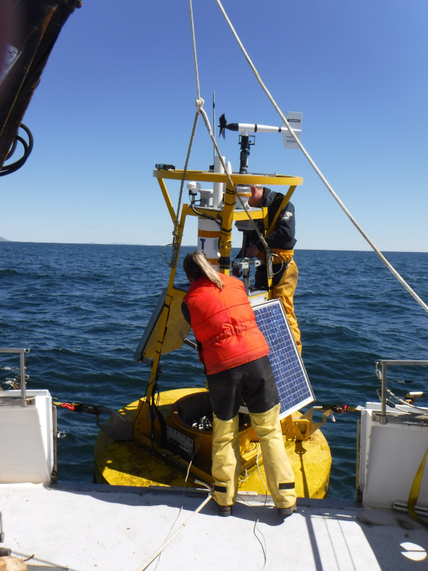
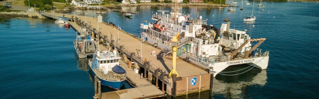
Fixed mooring buoys are the tried-and-true, bread and butter of the NERACOOS ocean monitoring network; buoys are useful in that they can be outfitted with all sorts of sensors that provide near real-time information on conditions both above and below water.
Some buoys have been collecting data from the same site for decades, which gives us an invaluable glimpse into the way the ocean environment has been changing over the years. You can find and download all our historical data over on our ERDDAP server, and if you’ve never used ERDDAP before, here’s a video tutorial.
The NERACOOS network of buoys are owned and operated by our partners at the University of Maine, University of New Hampshire, University of Connecticut, and Woods Hole Group.
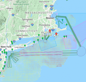
Tools like our Mariners’ Dashboard provide information from NERACOOS’s buoys, and also integrate buoy data from NOAA National Data Buoy Center, The Pioneer Array, and Mayflower Wind.
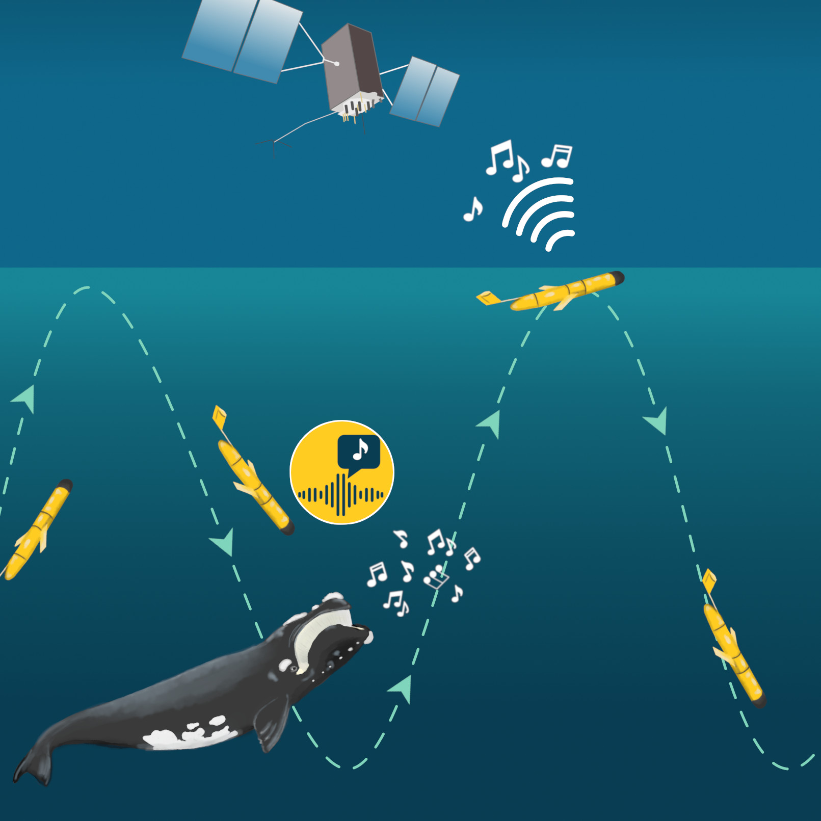
The scientists at Woods Hole Oceaographic Institute with whom NERACOOS partners are using gliders to detect the presence of marine mammals in the Gulf of Maine, though that’s certainly not the only job gliders perform. Because gliders can be customized with a variety of sensors, they can collect lots of different types of data throughout the entire water column.
Gliders, which are “autonomous underwater vehicles”, look like a cross between a mini submarine and model airplane. Once the glider has been programmed and launched, they roam along their predetermined route, collecting and transmitting data.
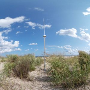
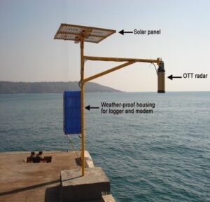
Did you know “radar” is an acronym for RAdio Detection And Ranging? High frequency radar (HFR) uses radio waves to map the direction and speed of ocean surface currents. NERACOOS’ system operators currently maintain 13 HFR stations; see their latest observations here. [link]
At first glance HFR data might not seem like anything special, but it’s actually used to do some pretty cool stuff, like:
When a boat or person goes missing, the Coast Guard or other rescue group looks at the behavior of surface currents to determine where someone may have drifted; based on that information, rescuers can narrow down their search area, and more quickly reach those who need help.
When there’s an oil spill, HFR forecasts are used to predict how hazardous waste will disperse around the spill site so that cleanup efforts can focus on the areas that are most likely to be impacted by the event.
Just as with an oil spill, HFR data are also used to help monitor water quality. If there’s a problem with wastewater or pollution discharge, resource managers can use HFR observations to decide whether or not public beaches and recreational areas should be closed to limit people’s exposure to nasty bacteria and chemicals.
Of course, HFR-provided info on currents is also really useful for mariners who need to know what kind of ocean conditions they’re likely to encounter.
The coast is an interesting place because it’s where the land’s effects run into the ocean’s influence, making that boundary a particularly active area. Compared to the open ocean, conditions on the coast can change significantly in a short span of time; coastal monitoring stations are able to constantly record shifts in conditions so we don’t miss a thing.
NERACOOS partners with the UNH Coastal Marine Lab, which supports many different types of marine research, including long-term monitoring of coastal and ocean acidification. The Marine Lab sits at the mouth of Portsmouth Harbor, making it an ideal place to track how runoff from land and fresh water inflow affects the ocean’s acidity.
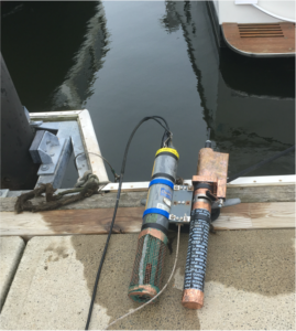
Coastal monitoring doesn’t start and stop at a seaside laboratory, though. Coastlines have a lot of already-built structures like municipal docks or pilings that make great homes for other kinds of sensors. For example, water level sensors use microwave radar to accurately measure tiny, tiny variations in the level of the ocean, which is useful for (among other things) tracking the progression of sea level rise.
Nutrient sensors, sometimes called water quality sensors, are another tool in the coastal monitoring toolbox. When sewage, waste and excess fertilizer flow from land into the ocean, the “nutrients” from that disgusting mix are fuel for the plants that cause harmful algal blooms, sometimes called red tide. As you might imagine, sewage and red tides greatly affect water quality, so monitoring for nutrients helps resource managers make important decisions. Lots of nutrients? Maybe close the beach so people aren’t swimming in poop.
For as long as there have been mariners, the same basic question has launched a billion ships: when is high tide? Safe navigation is impossible without accurate tide tables and predictions.